Other Aligning the RiverLands:

Selecting Demonstration Sites
Selection Process
It can be hard to imagine a 100-mile greenway trail and even harder to anticipate the transformative potential of such a huge project. To help put the greenway in context, this study explored several demonstration sites. For these specific locations, the Design Team provided conceptual designs in order to better understand, illustrate, and explain how the RiverLands greenway and its associated programs fit into the regional landscape, reflect the core RiverLands goals, and engage with local communities.
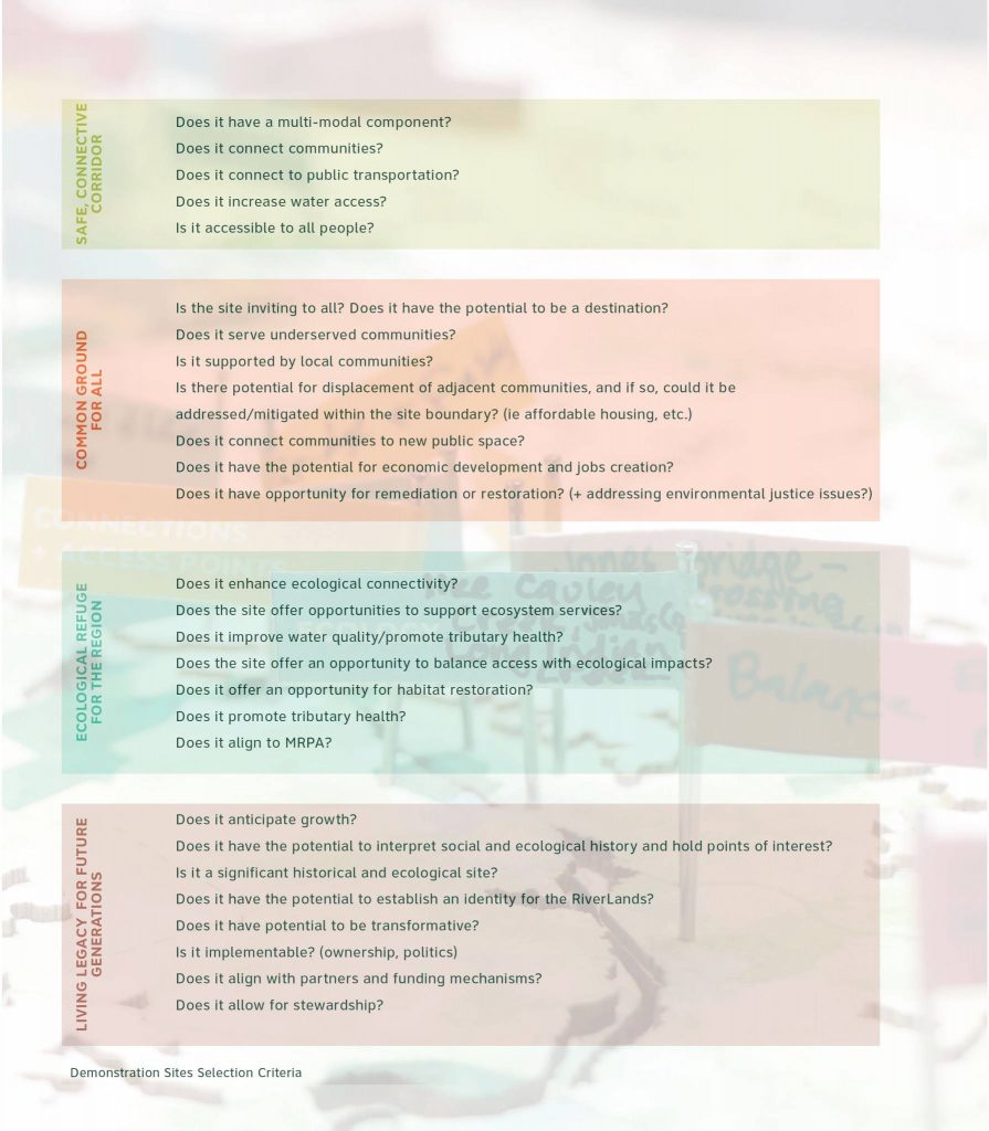
Based on Project Team conversations over the course of the Study, numerous potential Demonstration Sites were identified. Due to time and resource constraints, three sites were selected for more detailed studies. In order to choose the Demonstration Sites, the team developed evaluation criteria based on how well each site supports the RiverLands’ four project goals: to create a Safe, Connective Corridor; establish an Ecological Refuge; ensure a Common Ground for All; and provide a Living Legacy for the region.
Using the evaluation criteria, the Chattahoochee Working Group members were asked to evaluate the considered sites, and were tasked to help determine which sites could best demonstrate the Study’s goals and objectives. Ultimately, in collaboration with the Chattahoochee Working Group and stakeholders, additional design studies were conducted by the Project Team.
The Demonstration Sites are meant to be places where the RiverLands will become tangible and will establish models for the greenway development while showing the full breadth of the RiverLands’ vision.
Role of Demonstration Sites
The Demonstration Sites act as key destinations that bring people not only to the River’s edge but allow them to understand the identity of the RiverLands. These sites reveal the potential of the Chattahoochee RiverLands vision and represent typical conditions throughout the 100-mile corridor.
Geographic Distribution
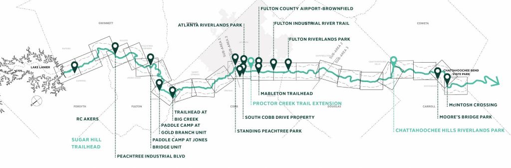
The selected Demonstration Sites are distributed evenly between the three sub-areas and act as examples for how to respond to typical conditions within the northern Suburban Parklands, central Urban Core of Atlanta and Cobb County, and the southern Agricultural Countryside.
Level of Design
The Demonstration Sites have been designed through collaboration with the Chattahoochee Working Group, Sub-Area Committees, and stakeholder input. The sites have been drawn to a conceptual level of design – suggesting programmatic overlays and key design elements of the RiverLands such as trailheads, water access points, tributary trails, and parks.
Demonstration Sites Considered
- Sugar Hill Trailhead (selected)
- RC Akers
- Abbott’s Bridge
- Settles Bridge
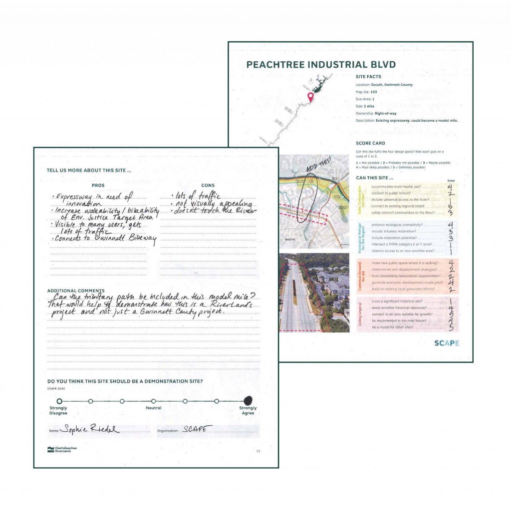
- Peachtree Industrial Boulevard
- Paddle Camp At Jones Bridge Unit
- Paddle Camp At Gold Branch Unit
- Trailhead At Big Creek
- Morgan Falls Overlook Park Extension
- Standing Peachtree Park
- South Cobb Drive Property
- Mcdonough-Atkinson Brownfield
- Atlanta RiverLands Park
- Proctor Creek Trail Extension (selected)
- Fulton Charlie Brown Airport
- Mableton Parkway Trailhead
- Fulton Industrial River Trail
- Fulton Riverlands Park
- Chattahoochee Hills RiverLands Park (selected)
- Moore’s Bridge Park
- Mcintosh Crossing
Demonstration Site Stakeholder Groups and CWG Meetings
The Chattahoochee Working Group was critical in determining which sites were selected to best demonstrate the Study’s challenges and opportunities. Members of the Working Group filled out worksheets in November 2019, evaluating each site and narrowed the selection to three sites – the Sugar Hill Trailhead, Proctor Creek Trail Extension, and the Chattahoochee Hills RiverLands Park.
In December 2019, three Stakeholder Groups consisting of landowners and technical advisors were established to provide background information and review concepts for the sites. Feedback indicated placement and types of program best suited for the demonstration site based on local knowledge and existing plans for the sites. For the Trailhead at SR-20, stakeholders expressed interest in connecting back to the Sugar Loop Greenway that is in development and plans for mountain biking in the area. For the Proctor Creek Trail Extension, stakeholders have been looking closely at the development of the Proctor Creek Greenway and were excited by the prospect bringing new energy to existing plans with the introduction of nature-based educational programming at the mouth of the creek. For the Chattahoochee Hills RiverLands Park, stakeholders expressed interest in utilizing higher ground that is less ecologically sensitive, connecting the greenway to the rest of the large park with a visitor’s center and boating outfitter located to the West and small primitive campsites scattered in the wetlands to the east.