
/-84.520390,33.789554,12/300x186@2x?access_token=pk.eyJ1IjoibHpjYW11dGkiLCJhIjoiY2o3a281dWJvMHE4ajMzbGF4enJyNHRiciJ9.DhYjvPk5E_wJvys5DU5v2A)
RiverLands Pilot Project
The RiverLands Pilot Project will test and demonstrate design strategies
Rooted in the spirit of the vision and goals for the RiverLands, The RiverLands Pilot Project will test and demonstrate design strategies to be employed over the entire 100-mile study area, while showcasing the rich cultural landscape and ecologically dynamic riparian system of the immediate locale. It will provide unprecedented access to this portion of the River, bringing people together and serving as a model for implementation of future RiverLands segments.
The RiverLands Pilot Project is a concept for a multi-modal trail on Cobb County-owned land along the west bank of the River, between Mableton Parkway and Veterans Memorial Highway. It will serve to test and demonstrate goals, design strategies, and material applications developed for the broader Greenway Study. While grounded in local context, the Pilot Project is also being developed as a regional destination which will showcase the potential of the entire RiverLands Greenway.
The RiverLands Pilot Project will give people the opportunity to see, interact with, and experience this diverse landscape in unique ways. This concept also sets the stage for future connectivity for the RiverLands by connecting to future tributary trails along Mableton Parkway and Nickajack Creek.
The diversity of topographical, ecological, and cultural resources along and within the Pilot Site present many challenges and opportunities for a greenway trail. One of the fundamental challenges of the Pilot Project, which is representative of the entire Chattahoochee RiverLands, is finding the right balance between increasing or enhancing access and preserving and conserving natural features, ecological habitat, and cultural resources. The Pilot Site falls within an ecologically dynamic riparian system and represents the kind of riverside ecology that has emerged as critical to preserving habitat and ecological functions in urban and urbanizing landscapes across the country.
A significant portion of the Pilot Site is within the floodway and much of the northwestern portion of the Pilot Site is jurisdictional wetland. The site is also characterized by several stormwater outfalls. Fortunately, the presence of a former roadbed and cleared utility easements provide opportunities to align the pilot trail while minimizing impacts to ecological and cultural resources, and can help to avoid issues with steep slopes and topography while also providing opportunities to improve the site ecology through restoration techniques like regenerative stormwater conveyance or seepage wetlands.

Developing the Pilot Project concept allowed the Design Team to evaluate site-level characteristics and think about trail components and how they can be knit together to form a cohesive system. This site-level exploration also enabled the team to consider placement and design of features and amenities, trail and water access points, resting areas, trailheads, and overlooks.
The RiverLands is comprised of a Preferred Alignment, tributary trails, water access points, and trailheads throughout the 100-mile corridor. The main trail, or Preferred Alignment, is the primary spine of the RiverLands. The tributaries provide key connections to nearby hubs of activity and destinations. Some are proposed to follow creeks, like Nickajack Creek, while others follow routes to public transportation, schools, and other destinations. The main trail and tributary trails are multi-modal for people to use while biking, walking, and traveling via other wheeled modes, such as a wheelchair or stroller. The pedestrian-oriented rambles are envisioned as natural surface trails that meander to provide a more rustic experience, opportunities for quiet exploration, and to bring people closer to wooded areas and vegetation.
Within specific sites along the main trail, there are opportunities for pedestrian-oriented rambles and site-specific nooks, which serve as places to stop and rest, pull off to the side of the trail, take a drink of water, or catch up with friends. Nooks may take many different forms depending on the context; they offer places for either passive or active recreation, exploration, gathering, learning, and recuperating.
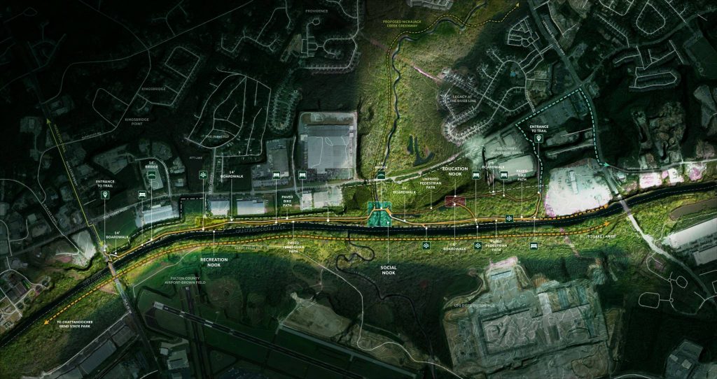
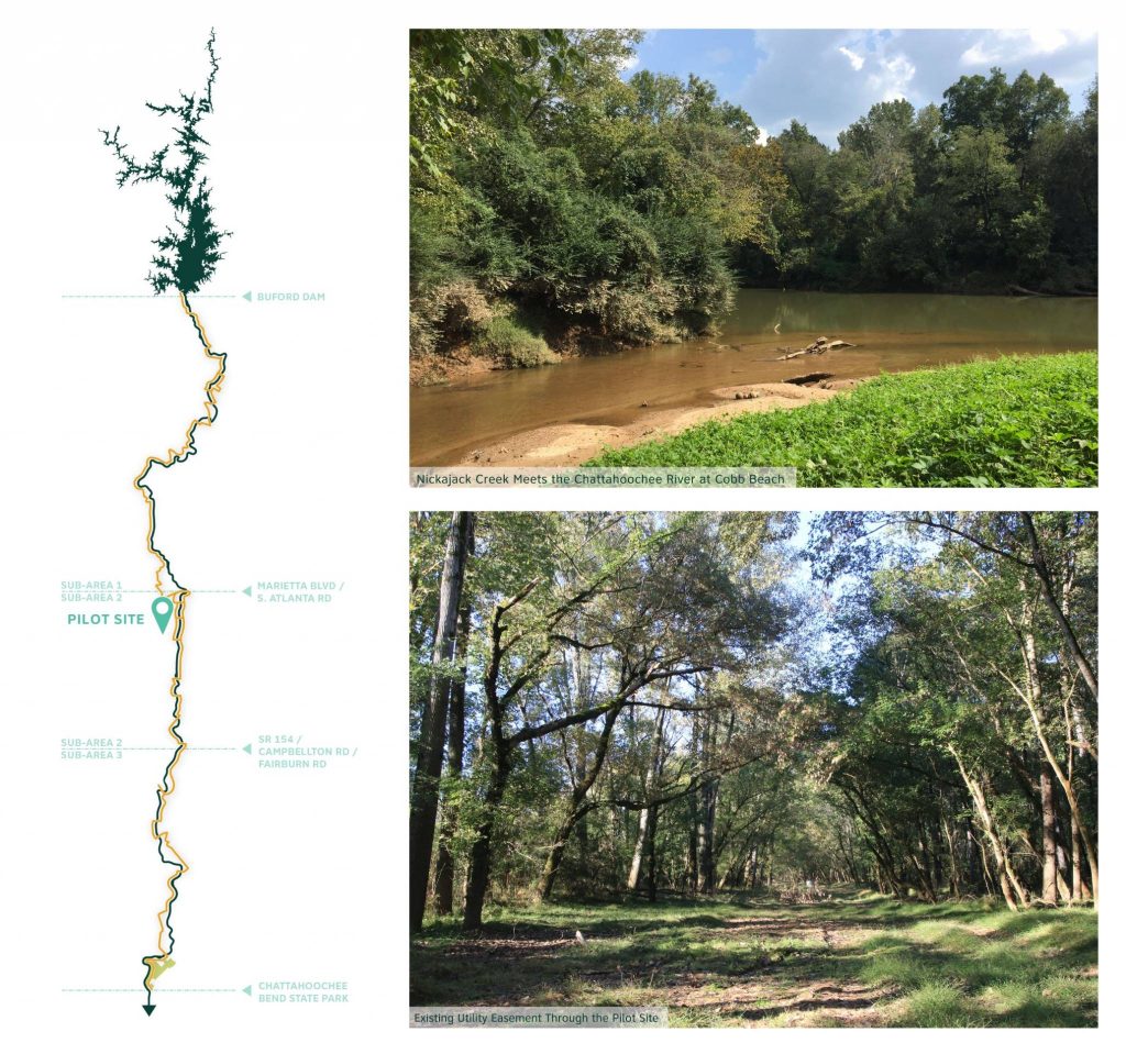
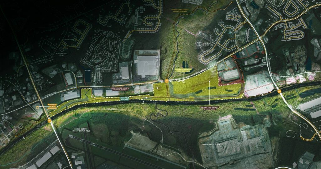
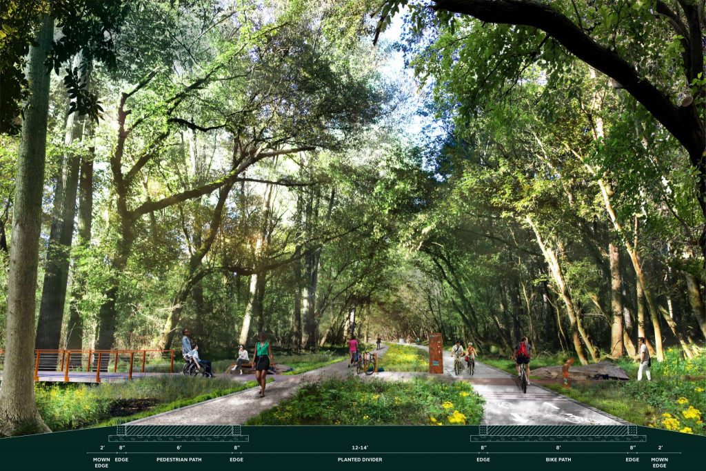
The RiverLands Pilot Project will construct approximately 2.4 miles of trail within Cobb County-owned land between Mableton Parkway and Veterans Memorial Highway. The trail begins at the southern end of the forthcoming Mableton Parkway Trail, south of Discovery Boulevard and continues past a former pump station, crosses Nickajack Creek, and meanders through wetlands upstream of the creek. It terminates at the northern boundary of the County-owned property, setting the stage for future connectivity to the North and West.
The Pilot Project consists of approximately 1.7 miles of paved multi-modal trail and 0.7 miles of unpaved pedestrian-only rambles. It provides a direct connection to the Cobb PARKS Discovery Boulevard Property trailhead, which will provide access to nearly one mile of additional footpaths, a small parking lot, two bus parking spaces, and a rustic restroom.
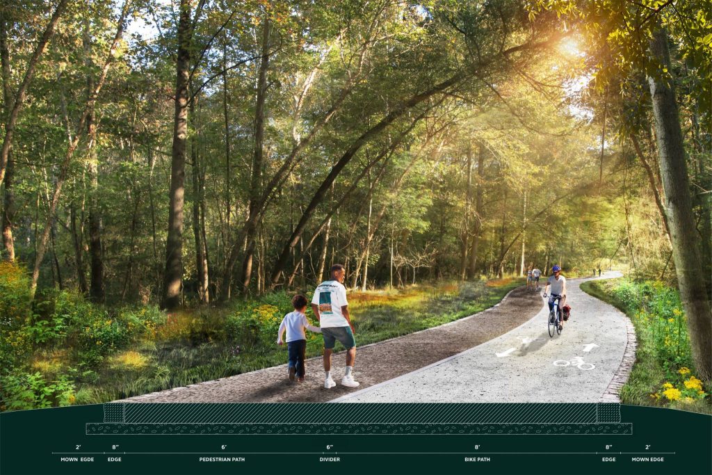
The trails are proposed as a combination of six-foot-wide paved and unpaved paths for pedestrians, eight-foot wide paved bicycle paths and fourteen-foot-wide multi-use trail for bicyclists and pedestrians. In some locations the multi-use path splits to minimize clearing impacts and avoid utility manholes, with six-foot paths for pedestrians and eight-foot paths for bicyclists. Several segments of boardwalk will facilitate movement over wetlands and in areas where reoccurring ponding water is likely, as well as over constructed wetland or stormwater improvements. Bridges are proposed across Nickajack Creek and over a smaller creek located in the southern portion of the site
Untreated stormwater outfalls, especially those that are visible from the trail or causing erosion, will be treated with nature-based stormwater Best Management Practices that allow infiltration and improve water quality, such as sand seepage berms or step pools.
Designed for all ages, abilities, and users, the RiverLands Pilot Project relies on intuitive design that responds to human behavior. It will forge human connections to the River and local ecologies, and evoke a sense of history, community, and stewardship through opportunities for direct access and engagement with the water and other site features. It is also an opportunity to demonstrate interagency collaboration by exploring and working with utilities, County agencies, and the Metropolitan River Protection Act to determine how to provide high quality public space and improve ecological conditions while working within the bounds of the regulatory landscape.
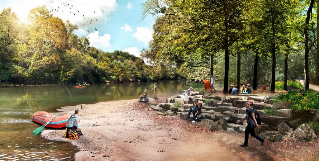
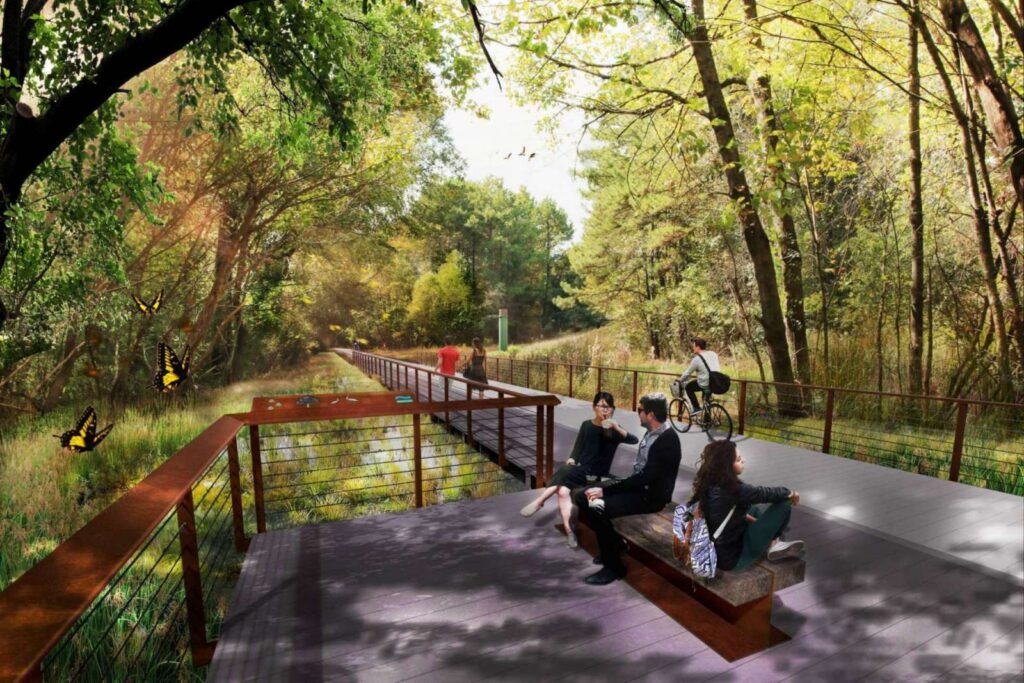
The area at the confluence of Nickajack Creek and the Chattahoochee River, sometimes casually referred to as “Cobb Beach,” is envisioned as a Social Nook – a space for gathering, resting, educational programming, and direct water access. The Social Nook will reflect the colors and palette of materials occurring in and around the Chattahoochee River, with elements of wood, rock, and light touches of metal inspired by the wooded areas, shoals, Georgia red clay, and the River itself. Proposed key features of the concept include:
- Entry and gathering space at the foot of the Cobb Parks Discovery Boulevard Property upstream of Nickajack Creek
- Natural footpaths for forest exploration upstream of Nickajack Creek
- Direct water access and “get downs” with possible kayak access
- An elevated overlook to provide views of the river
- Shaded areas and seating
- Landscaped areas
- Small structure or comfort station
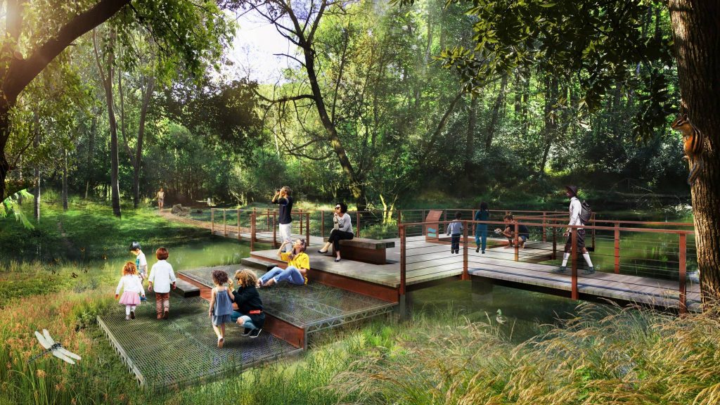
The pedestrian ramble upstream of Nickajack Creek gives trail users an opportunity to experience a different part of the Chattahoochee River ecosystem. Traversing wetlands and threading through wooded areas, the ramble is a perfect opportunity to create an outdoor classroom. Located off the western arc of the pedestrian ramble, the Education Nook is envisioned as a place for small groups to gather, listen, explore, and learn. Visitors to the area will be able to get down and interact with the flora and fauna along a series of pull-offs that invite visitors to step off the trail and explore their surroundings.
The boardwalk trail will feature a “wetland window” that provides a glimpse into the spaces below the surface of the boardwalk. Proposed features of the concept include:
- Boardwalk trail surface
- Multiple pull-offs
- A small gathering place with natural material seating
- A “wetland window” that allows visitors to peer over the edge of the boardwalk into the wetlands below
- Landscaped areas
- Direct connection to the main Pilot Project trail along the River